Directions for following the Muir Ramble Route
Section One
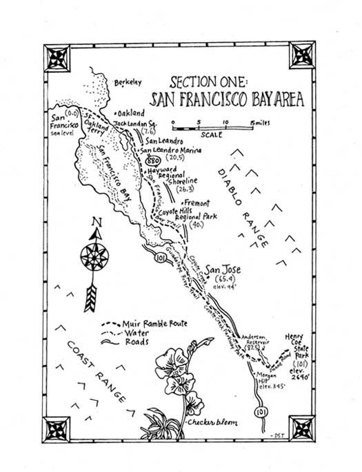
Section One: San Francisco to Morgan Hill
Begin: Davis and Broadway, San Francisco.
End: Henry Coe State Park (HCSP), Morgan Hill.
Distance: 101 miles.
Trip description:
Section one of the MRR begins in San Francisco and ends just east of Morgan Hill at Henry Coe State Park. The trip starts crossing the bay by ferry, passes through Jack London Square then heads south on the Bay Trail through Alameda County. The trip continues through Santa Clara County on bike trails and city streets following Coyote Creek and the Guadalupe River. It ends traveling a few miles east of Muirs actual route to access the wilderness preserved by the creation Henry Coe State Park. This is the most urban section of the Muir Ramble Route: about two thirds is through parks or on trails, the rest is on city streets and the contrast between the past and present is more obvious here than anywhere else on the MRR. It is also probably the easiest section to travel, the landscape is flat and the climate is more moderate than in any other section. The Bay Trail is now about three-quarters complete, and when finished will be a 400-mile bike and walking path that circles the entire bay. It is intermittent through Alameda County. Sometimes it wanders through the wilds of a shoreline park, past flocks of shorebirds stalking in the bays shallow tidelands, giving access to the bay areas wetlands,. Other times it follows a city sidewalk or bike lanes past rangy industrial buildings and city streets. It finds accesses through hotels, condominium complexes and warehouses, using unlikely-looking paths or gravel roads, and reveals hidden panoramic views of the bay, the Oakland hills and San Franciscos city skyline from these unusual vantage points. The Bay Trails wanderings may cause the directions through Alameda County to seem very complicated, but when walking they are really very easy to follow and you can always just keep heading south like Muir did, staying between the Diablo and Coast ranges until they begin to come together near Gilroy. The first time we rode this section on bikes we were joined by a bay area couple who had recently cycled in France. They enjoyed seeing the beauty of their own backyards, the shorebirds on the bay, the vast landscapes of flowering fields in the valley and the oak lined trails along the river bike trails. We bought wine and cheese in a little store for lunch, spent the nights in hotels and used public transportation to start and end the trip. The trip was a complete success and afterwards our friends even claimed that at a fraction of the cost the MRR rivaled their European cycling. Before that neither Donna nor I had ridden more than ten miles in a day. But since the weather was mild, the landscape flat, the scenery engaging and the company enjoyable, it was no problem for us to pedal the 15 50 mile days, and we imagine any reasonably fit person with little cycling experience could do it too. In 2008 we walked this section with a group of students from the Environmental Studies department at De Anza College. They were working to assure that the Coyote Valley, near Morgan Hill, was preserved as open space for animals to migrate from the Santa Cruz Range to the Diablo Range, and planned the trip to culminate in a rally in Coyote Valley, where public and the media could learn about their mission. It was a 5-day urban backpacking trip and we averaged 15 miles a day. Most of the students had never backpacked before and this was a seminal outdoor experience for them. We carried packs, slept in churches, shelters and private homes on or near the route. After the walk they gave a presentation to the student body, and what they shared gives a sense of their experience: This MRR trail is more than recreational, it is a way to get from one place to another. One person with a backpack in the city is usually seen a vagrant, a danger, but ten people with backpacks becomes a kind of statement. A lot of people smiled when we hiked by. We inspired their imagination. We walked through a lot of amazing parks and beautiful open space. We even spent about a half of one day walking on city streets and some of the big ones didnt even have sidewalks. That was important in the context of the whole walk; to see how much land is dedicated to streets, business parks, housing tracts and auto malls and how little to nature and foot traffic. We experienced how hard it is for a person to get from one place to another because of all the freeways and bridges and buildings. Think how much harder it must be for the animals that want to migrate.
Recommended Trip:
Begin: Oaklands Clay Street ferry landing, near Jack London Square. (MRR mile 7.6) End: Terminus of the Coyote Creek Bikeway in Morgan Hill. (MRR mile 86.9) Distance: 80 miles The recommended trip begins in Oakland at the modern ferry landing near Jack London Square and ends at the south terminus of the Coyote Creek Trail near Anderson County Park in Morgan Hill. You could, like Muir, start in San Francisco, but the added logistics make it hard to recommend this for the person with limited time. The trip can be done as a 2 or 3-day bike ride or a 6-day walk. We recommend you use public transportation and make it a round trip. Just leave your car at the Fremont Bay Area Rapid Transit (BART) station, take BART to Oakland, walk or cycle to Morgan Hill, and then take a bus back to the Fremont BART station. The route follows the Bay Trail through Alameda County. The route continues through Santa Clara County following the Coyote Creek Bike Path along the sycamore and cottonwood-lined riparian river corridor, then on city street through business parks near the airport then connects with the Guadalupe River Trail which ends in downtown San Jose. The MRR crosses downtown San Jose from west to east on city streets then connects up with the Coyote Creek Trail, an 18 mile bike path that follows along the wonderfully still natural and richly verdant Coyote Creek river corridor to its southern trailhead in Morgan Hill. If you take the recommended trip on a bicycle we suggest you leave from Oakland after work on a Friday. That makes day one an easy 13-mile ride to a hotel at the San Leandro Marina. Day two is a 42-mile ride to downtown San Jose where there are many hotel options. The third day is a 20-mile ride to the ending trailhead in Morgan Hill and there will be plenty of time to take public transportation back to the beginning trailhead. Experienced street riders often peddle up to Henry Coe State Park for exercise so we can recommend the trip up for the serious cyclist. This also makes a wonderful and challenging 6-day walking trip. We recommend you leave early the first day and a 13-mile walk will get you to the San Leandro Marina Inn. The second day an 18-mile walk will get you to the campground at the Coyote Hills. The third day a 10-mile walk will get you to a hotel right on the route in Hayward. If you dont want to camp, this could be done as two 14-mile days, staying in a hotel less than a mile from the route in the Union City region of Fremont. The fourth day a 16-mile walk will get you to downtown San Jose (this will be about 4 miles shorter when the detour is eliminated. The fifth day a 10-mile walk will get you to a hotel on Silicon Valley Blvd. The last day is an easy 10-mile walk to the ending trailhead in Morgan Hill, and if you leave early there will be plenty of time to take a taxi to the bus stop and the bus back to the BART station. East Dunne Road is steep, small and winding and we do not recommend walking up to Henry Coe State Park.
What you need and need to know: Maps: San Francisco Bay Trail Maps: East Bay - Richmond to Hayward, South Bay - Redwood Shores to Newark. Look online for ordering info. Coyote Creek and Guadalupe River Trail Maps: look online for printable maps. Park maps: Santa Clara County Parks Map: Anderson County Park. Henry Coe State Park map available through the Pine Ridge Association website online. Accommodations: There are many hotels in the metropolitan areas adjacent to the route and these can be located by searching using the Internet. The lodging for the recommended trips are noted in the directions then listed as resources at the end of the section. There is camping at Coyote Hills Regional Park (groups only) and at Henry Coe State Park. Food and Water: Carry food and water with you. There are a few stores directly on the route, and more can usually be found within a mile or so from the trail. There are water fountains and rest rooms in every park the route passes through, but they may not all be in service.
Section One Directions: (0.0) The Muir Ramble Route begins in San Francisco at the intersection of Davis and Broadway Streets. Head east on Broadway. Go 1 block. Note: This is where the San Francisco-Oakland Railroads ferry terminal was in 1868. Since then the bay has been filled in, and this is now a full city block from the water. (0.1) Turn right on Embarcadero. Go .4 miles. (0.5) Turn left into the Ferry Plaza. Go .1 mile, past the Ferry Building to South terminal Gate E. (0.6) Take the Oakland/Alameda ferry to Jack London Square. Go 7 miles across the bay. The first stop is in Alameda. Get off at the second stop, which is in Oakland at the end of Clay Street, near Jack London Square. Note: Look online for schedules and fares. Bikes are allowed on the ferry. (7.6) Leave the Oakland ferry landing at the end of Clay St. Go one hundred feet to the intersection of Clay and Water St. Note: This is the trailhead for the suggested bike and walking trips. In 1868 the Oakland terminal was near present day Seventh and Wood Streets. The shoreline was so shallow that the SF-Oakland RR had constructed a wharf stretching three-quarters of a mile into the bay to avoid the problems caused by tidal changes. Passengers and goods were loaded on a train that took them down the wharf and into Oakland. There was a West Oakland station near the terminus, a stop at Seventh Street and Broadway and then a stop called "Brooklyn", near the intersection of Fourteenth Street and Fourteenth Avenue. Muir states he left the train in East Oakland, so we believe Muir did not get off at Seventh and Broadway, and that the "first road he came to" was Fourteenth Street. (7.6) Turn right. Go 1 mile, continuing south, past Jack London Square and through Estuary Park. Note: Jack London didn't spend time here until the 1880s, and in Muir's day the area was just docks and shipyards. As you head south along Water St. look to your right for blue and white enamel signs that say San Francisco Bay Trail. These signs will lead you off Water St. on the BTs intermittent dockside trail. Look for those Bay Trail signs! Estuary Park has picnic grounds and restrooms. (8.6) Turn right on Embarcadero Ave. Go .7 miles, using sidewalks or the bike lane. (9.3) Turn right on 10th St. Go .1 mile, cutting through the Hilton Hotels parking lot to another section of the BT beside the bay. (9.4) Turn left. Go .4 miles, following the BT south past the hotel until it ends at Marine Max. (9.8) Turn left. Go .1 miles, returning to Embarcadero. (9.9) Turn right. Go .1 miles, stop just before reaching the Executive Inn Suites. (10.0) Turn right. Go 200 feet. Following the BT to the bay. (10.0) Turn left. Go .4 miles following the BT between the hotel and the water till it ends in the Embarcadero Cove Marina. (10.4) Turn left. Go 200 feet, through the buildings and parking lot, back to Embarcadero. (10.4) Turn right on Embarcadero. Go .2 miles, stopping just past the intersection with Livingston Street on the left. (10.6) Turn right onto the BT. Go .3 miles following it around through Union Point Park. Note: The park is landscaped with native plants, architecturally interesting play areas and sculptures. There is water and restrooms. Embarcadero becomes E. 7th St. after the park. (11.0) Turn right onto 7th St. Go .2 miles. (11.2) Turn right on 23rd Ave. Go .2 miles, then cross over to 29th Ave. (11.4) Turn right on 29th Ave. (11.4) Follow BT for .4 miles (11.6) Turn left on Lancaster St. Go .2 miles. (11.8) Turn right on 7th St. Go 1 block. (11.8) Turn right on Fruitvale. Go .2 miles. (12.0) Turn left onto BT. Go .4 miles. (12.4) Turn left on High St. (12.4)Turn right on Tidewater. Go .2 miles (12. 6) Turn left onto BT. Go .5 miles (13.1)Turn right and enter the Martin Luther King, Jr. Regional Shoreline. Note: The Martin Luther King, Jr. Regional Shoreline, part of the East Bay Regional Parks, wraps around the edge of San Leandro Bay. Its extensive and protected marshlands provide a stopover for migrating birds on the Pacific Flyway. The park has picnic facilities, drinking water, restrooms, a sunbathing beach and childrens play areas. (14.0) Cross the East Creek Slough bridge, turn right again and stay near the waters edge. Go .7 miles. (14.7) Cross a bridge over the Damon Slough then turn right. Go .8 miles, following the Garretson Point Trail, past picnic tables, water and restrooms. (15.5) Cross the bridge over Elmhurst Creek then turn right. Go .1 miles following the waters edge. (15.6) Cross the bridge over San Leandro Creek then turn right. Go 1.1 miles along the Arrowhead Marsh Trail, past the observation tower and restored marsh areas. (16.7) The path ends at Swan Way and Doolittle Dr. Note: You are near the Oakland International Airport with hotels and restaurants close by. (16.7) Turn left on Doolittle Dr. Go .5 miles. (17.1) Cross Doolittle and follow the BT for 1 mile. (18.1) Cross the San Leandro Slough Bridge to enter the Oyster Bay Regional Shoreline. Go left for a shorter path to Neptune Dr. (.9 miles), or go right to follow the Bay to Neptune Dr. (1.6 miles) The Oyster Bay Regional Shoreline, a 157-acre park built on a landfill that was closed in the early 1980s. The Bay Trail runs around the edge of the park in a semicircle along the Bay, and the views are spectacular. Picnic sites are located on the hill. Water and restrooms are located at the southern entrance on Neptune Drive. Marsh hawks, black-shouldered kites, red-tailed hawks, and shorebirds abound in this East Bay Regional Park. (19.9) The Shoreline Trail ends. Turn right on Neptune Drive. Go .6 miles. (20.5) Turn right on Monarch Bay Drive. Go .7 miles, continuing past the San Leandro Marina and the Shoreline Recreation Area, stopping when the street ends at a golfcourse. The San Leandro Shoreline Recreation Area, managed by the city of San Leandro, has great walking trails. It also has play areas, picnic tables, restrooms and water. (21.2) Veer right onto a pedestrian path. Go 2 miles, crossing a bridge over Estudillo Flood Control Canal and following the BT along a bike path between a golf course and the water. Note: This bike path passes through the restored marshland areas of San Leandro. Mile and half-miles are painted on the pavement. (23.2) Turn right at the Heron Bay signpost. Go .7 miles, passing between a large housing subdivision and the tidal wetlands, turning right when you come to the San Lorenzo Creek. (23.9) Turn left and cross the creek on a wooden bridge. Go 2.4 miles, staying close the waters edge on the BT as it crosses Bockman Channel, Sulpher Creek and a flood control channel then turns inland to circle around Cogswell Marsh. Note: You are now in the Hayward Regional Shoreline, a 1,713 acre park that is part of the East Bay Regional Parks. The tidal marshlands were used by Native Americans to make salt and in 1868 there were 18 small commercial salt production operations between here and Alameda Creek, which runs just north of Coyote Hills. You will be passing remnants of those salt ponds and the landings used to ferry goods to San Francisco. (26.3) Turn right at an intersection where you see a City of Hayward No Trespassing sign posted straight ahead. Go 2.2 miles, staying near the bay until the trail turns inland to reach the Shorelines trailhead near the Hayward Regional Shoreline Interpretive Center. Note: In .4 miles after crossing a bridge over Cogswell Marsh the trail splits. Take either fork; both end at the same place. The Interpretive Center has displays of the natural and cultural history of the area, restrooms and water. (28.5) Turn left onto the freeway frontage road. Go .3 miles. (28.8) Turn left at the entrance to the pedestrian bridge. Go .2 miles, crossing over Highway 92. (29.0) Turn right, and the BT follows Point Eden Way. Go .6 miles. (29.6) Enter the Eden Landing Ecological Reserve. Go .6 miles. (30.2) Turn right on Dune Circle, then left on Shellgate Circle. Go .1 mile. (30.2)Turn right on Sandcreek Dr, the left on Eden Shores Blvd. Go .6 miles. (30.8) Turn right on Hesperian Blvd. Go 4 miles. Hesperian becomes Union City Blvd. after crossing Alameda Creek. (36.0) Cross the bridge over the Alameda County Flood Control Channel. Turn right and enter the Coyote Hills Regional Park. Go 1.8 miles following the Alameda Creek Trail parallel to the flood control channel. Note: The Coyote Hills Regional Park is nearly 1000 acres of marshland and rolling grassland-covered hills. There are boardwalks winding through the wildlife-rich wetlands, and you can hike to the top of one of the peaks here for great views in all directions. It has 2 campsites, one for groups near the visitor center, the other at the south end. You may reserve them through the East Bay Regional Park District office. (37.8) At the northern foot of Coyote Hills turn left and go up the hill on a connector trail. Take the next right, which is the Bayview Trail. Go 1.7 miles to the west and then south, wrapping around the hills for some fantastic views of the Bay. (39.5) At the fourth trail junction, turn right on the Apay Way. (Continuing straight ahead will take you to the Dairy Glen group camp). Go .5 miles. Note: The trail name changes to the Quarry Trail as it winds up towards Highway 84 and passes the old gravel quarry, which is now the Dumbarton Quarry Campground. (40.0) After passing the campground, the trail splits. Stay left for better views. Go .5 miles. (40.5) The Coyote Hill bike trail ends. Cross Highway 84 on a pedestrian bridge. Turn right onto a park service road, then left (south) onto unsigned Marshlands Road. Go .1 miles, past the Newark Slough Learning Center parking lot, to the Don Edwards San Francisco Bay National Wildlife Refuge visitor center parking lot on the right. Note: The wild area to the west of Marshlands Road and south of the freeway is part of the Don Edwards San Francisco Bay National Wildlife Refuge, a huge refuge that encompasses 30,000 acres of mudflats, salt marshes, open land and bay. (40.6) Turn right on the unsigned Tidelands Trail. Go .2 miles, past the visitor center, up to the Hilltop Overlook. Note: The visitor center has both historical information panels and natural history displays. Open Tuesday through Sunday, 10:00 a.m. to 5:00 p.m. From the overlook you can see south all the way to Gilroy. Note how the Diablo and Santa Cruz mountain ranges come together, just as Muir described in his account. (40.8) Continue down the Tidelands Trail .3 miles. (41.1) Make a sharp left turn on Harrier Spur Trail. Go .3 miles. (41.4) Turn right on an unsigned paved county road (Marshlands Road). Go .3 miles. (41.7) Turn right on Thornton Avenue. Go 1.9 miles. Note: On a busy road like this which does not have bike lanes or sidewalks, walk on the left side of the road, facing the traffic, and cycle on the right, with the flow of traffic, claiming the full right lane when there is no shoulder. There is currently has no alternative for the MRR but to follow busy city streets for the next 5.8 miles. It is a fine bike ride, but if walking you might want to consider taking a bus or taxi. The closest bus stop is at Thornton Ave. and Sycamore St. Take AC Transit bus #214 to the Fremont BART station, then the #212 south to Fremont Blvd and Cushing Parkway, about a one hour trip. (43.6) Turn right on Cherry Street. Go 5.7 miles. Note: Cherry becomes Boyce Road at Stevenson Blvd, then Cushing Parkway at Auto Mall Blvd. Note: The Newark Sportsfield Park, with restrooms and water, is on the right. (49.4) Turn right on Fremont Blvd. Go .7 miles. (50.1) Turn right on an unmarked gravel service road located near 46600 Fremont Blvd, just before the first signal at West Warren. Go .2 miles. (50.3) Turn left on a second gravel road, just before reaching a small city park. (No water or restrooms). Go .3 miles. Note: This is the northern trailhead for the Coyote Creek Lagoon day use area, where the BT follows jogging trails along its levees. It is 260 acres of restored marsh, including a 25 acre native pickleweed stand, and the wetland views are stunning, and surprising given the industrial surroundings. (50.6) Turn left at a T junction. Go 1.4 miles. (52.0) Turn left at a T junction. Go .4 miles to the parking lot and trailhead. (52.4) Turn right on Fremont Blvd. and cross the slough. Go .7 miles. (53.1) Go straight ahead to McCarthy Blvd. Go .3 miles, crossing Coyote Creek twice, to BT. (53.4) Turn right immediately after crossing the second bridge at the signed entrance for the Coyote Creek Bike Trail. Go 2.2 miles, following the trail south. (55.6) The Coyote Creek Bike Trail ends just west of the McCarthy Ranch Shopping Center. Turn left, go through the parking area, turn right on McCarthy Blvd. and go .3 miles, crossing over Highway 237. (55.7) Turn right on the Highway 237 Bikeway, a highway frontage road for bikes and pedestrians. Go .3 miles. (56.0) Turn left after crossing Coyote Creek, pass through a chain link gate and immediately turn right onto the dirt road. Go 1.3 miles. Note: This is a section of the Coyote Creek Bike Trail. It follows maintenance roads along the creeks west bank. The low road, being closer to the river, is better for walking. (57.3) Turn right on Palazzo Dr at Pocket Park. Go .1 mile. (57.4) Turn right on River Oaks Parkway. Go .9 miles to the Guadalupe River Trail. (58.3) Go left onto the Guadalupe River Trail. Go south 2.8 miles, following the trail on the east side of the river. Note: The Guadalupe River Trail, managed by San Jose City Parks, follows the river for 11 miles, from Alviso to Lake Almaden Park. (61.1) Cross to the west side of the river at Airport Parkway. Go 2.3 miles, following the trail south into the Guadalupe River Park. (63.4) Just before Coleman Avenue, when the trail splits in two, take the right fork (just past a rock wall on the west side of the trail). Go 100 feet. (63.5) Turn left on Coleman Ave, cross the bridge and continue south following the trail on the east side of the river. Go 1 mile. (64.5) Turn left on Santa Clara Street. Go .4 miles. Note: This is the old downtown San Jose. In the California History room of the MLK public library there are photographs on the wall taken here in 1868. Downtown has good places to eat and spend the night. (65.8) Turn right on Market Street. Go .1 miles. (65.9) Turn left on San Fernando St. go .7 miles. (66.6) Turn right South 10th Street. Go .5 miles. (67.1) Turn left on East William St. Go .5 miles. (67.6) Turn right and enter the Coyote Creek Trail and William Street Park. Go 1 mile following a section of the Coyote Creek Trail through the school and picnic areas then curve to the right and pass under the 280 freeway. Note: This trail is part the Coyote Creek Parkway, under the jurisdiction of Santa Clara County Parks. There are restrooms beyond the playgrounds near the ball field. (68.1) Turn right on Remillard Ct. Go .1 miles. (68.2) Slight left on Story Road. Enter the Coyote Creek Trail. Go .8 miles, passing through the Vietnamese Heritage Garden. (70.) Go left on Phelan Ave. Go .1 mile. (70.1)Turn right on Lucretia Ave. Go .5 miles. (70.6) Turn right on Summerside Dr. Go .2 miles. (70.8)Turn left on Galveston Ave. Go .3 mile. (71.1)Go right on Coyote Creek Trail. Go 1.7 miles. (72.8) Turn left at a T junction and go under the Capitol Expressway to stay on the trail. Go .3 miles. (73.1) The trail crosses to the west side of the creek. Go .2 miles. (73.3) Turn left at a sign for the Coyote Creek Trail. Go .9 miles passing under Yerba Buena St. Follow the trail through Hellyer Park, passing west of the velodrome then passing restrooms with water on the left. (74.2) When the trail forks stay right. Go .7 miles, continuing on the Coyote Creek Trail, skirting around Cottonwood Lake. Note: Just west of the fork is a visitor center with a live rattlesnake. In the next few miles the trail passes by several magnificent old valley oaks. (73.9) The trail passes under Highway 101. Go .7 miles. (74.6) The trail crosses the creek on an old bridge. Go 1.6 miles. (76.2) The trail passes under Silicon Valley Boulevard. Go .7 miles. Note: This is a good days walk from downtown San Jose and the Holiday Inn San Jose-Silicon Valley is just steps from the trail. There is a good restaurant here too. (76.9) The trail passes under Highways 101 and 85. Go .6 miles. (77.5) Pass Metcalf Park, with restrooms on the right. Continue .9 miles, past Coyote Parkway Lake, then cross the creek on a covered bridge. (78.4) Cross Metcalf Road turn left then right, following the signs for the Coyote Creek Trail. Go .8 miles. (79.2) Turn left on Coyote Ranch Road. Go .2 miles. (79.4) Turn right at the T junction. Go 5.1 miles, crossing the creek several times as you continue on the Coyote Creek Bike Trail. (84.5) Pass the Santa Clara Model Aircraft Skyport on the left. Go 1.6 miles. (86.1) The road forks at the Walnut Rest Area. Go .2 miles. Hikers follow the Sycamore Nature Trail right, cyclists stay left. These trails merge at a bridge. (86.3) Cross the bridge. Go .5 miles. (86.8) The Bike Trail ends at Eagle View Drive. Go one block south on Eagle View Dr. (86.9) Turn left on Morning Star Drive. Go one block. Note: This is the end of the recommended trip. We suggest you shuttle from here up to Henry Coe State Park, where the next recommended trip on the MRR begins, because East Dunne Rd. is 14 miles of twisting, narrow, dangerous, one and a half lane road. That said, we met a local cyclist, training for Olympic-type events, who rides it daily for exercise! You can take a Yellow Cab Taxi. Directions for returning to the Fremont BART Station: Follow Malaguerra Avenue southeast .3 miles. Turn right on Cochrane Road. Go 1.9 miles. Turn left on the Monterey Road. Go .5 miles, passing under the railroad tracks. Turn right on Old Monterey Road. Go .2 miles. Turn left on Llagas Road. Go .2 miles to Hale Road. The Valley Transit Authority VTA bus stop is at the northeast corner of the intersection. Take the #68 bus (it has bike racks on the front) north to the Diridon Transit Station in downtown San Jose. Take the Express 180 bus to the Fremont BART Station and to your car. (87.0) Turn right on Malaguerra Ave. Go .5 miles. (87.5) Turn left into Anderson County Park's oak shaded picnic area. Go .4 miles, following the Serpentine Trail beside the creek up to the Anderson Dam. Note: Anderson County Park is part of the Santa Clara County Park system. It has hiking trails, picnic areas and provides access for both boating and fishing in the 1,250 acre Anderson Reservoir. Bikes are not allowed on trails in the park. Note: Directions for bicycle route: Continue on Malaguerra. Go .5 miles. Turn left onto Cochrane Rd. Go 1.5 miles. Turn right on E. Main Ave. Go .3 miles. Turn left on Hill Rd. Go 1.1 miles. Turn left on East Dunne Rd. Go .8 miles Connect with the MRR at mile 91.8. (87.9) Turn right. Go .4 miles, crossing the dam and following the reservoir's edge to the boat launch area. Note: The boat launch area has restrooms and water. (88.3) Turn right. Go 1.4 miles, crossing the parking lot to the dirt road (Laguna Seca Trail) that leads up into the parklands. Follow the trail south and then east, to a residential area called Holiday Lake Estates. (89.7) Turn right on Holiday Dr. Go 2.1 miles following it through subdivision. (91.8) Turn left on East Dunne Rd. Go 9.2 miles. Note: This is a steep winding two-lane road with a narrow shoulder. Be extra careful. There is an outhouse on the east side of the reservoir at a fishing spot called Woodchoppers Flat. (101.0) End at Henry Coe State Parks Coe Ranch Headquarters.
Resources For Section One:
Maps:
California State Auto Association (AAA) www.csaa.com The Bay Trail Project 101 8th Street Oakland, CA 94607 (510) 464-7900 www.baytrail.org
Transportation:
San Francisco Muni 11 South Van Ness Avenue
San Francisco, CA 94103
(415) 701.2311
www.sfmta.com
Alameda/Oakland Ferry www.eastbayferry.com
BART Bay Area Rapid Transit District
P.O. Box 12688
Oakland, CA 94604-2688
(510)465-2278
www.bart.gov AC Transit Oakland office:
1600 Franklin Street
Oakland, CA 94612
(510)891-4706
www2.actransit.org
Accommodations:
Marina Inn on San Francisco Bay
68 Monarch Bay Drive
San Leandro, CA 94577
(510) 895-1311
www.slmarinainn.com
Marina Community Center
15301 Wicks Blvd.
San Leandro, CA
94579
(510) 577-3462
www.sanleandro.org
Courtyard Newark Silicon Valley
34905 Newark Blvd
Newark, CA 94560
(510) 792-5200
www.marriott.com/
Good Nite Inn Fremont
4135 Cushing Parkway
Fremont, CA 94538
(510) 656-9307
www.goodniteinnsanjose.com
Pacific Motor Inn- San Jose
455 South 2nd Street
San Jose, CA 95113
(408) 298-3500
www.pacificmotor.site
Hotel San Jose
399 Silicon Valley Blvd.
San Jose, CA 95138
(408) 770-6635
Organizations:
The Bay Trail Project
101 8th Street
Oakland, CA 94607
(510) 464-7900
www.baytrail.org
East Bay Regional Park District Headquarters
2950 Peralta Oaks Court
PO box 5381
Oakland, CA 94605
(888) 327-2757
www.ebparks.org/parks/hayward
Hayward Shoreline Interpretive Center
4901 Breakwater Ave
Hayward, CA 94545
(510) 670-7270
Don Edwards San Francisco Bay National Wildlife Refuge
2 Marshlands Rd.
Fremont, CA 94555
(510) 792-0222
www.fws.gov/refuge/don-edwards-san-francisco-bay
Coyote Hills Regional Park
8000 Patterson Ranch Road
Fremont, CA 94555
(510) 544-3220
www.ebparks.org/parks/coyote-hills
Coyote Creek Trail
Guadalupe River Trail
www.sjparks.org/trails
History San Jose
1650 Senter Road.
San Jose, CA 95112
(408) 287-2290
www.historysanjose.org/visiting_hsj/history_park/
Hellyer County Park:
985 Hellyer Ave.
San Jose, CA 95111
(408) 225-0225
www.parks.sccgov.org/santa-clara-county-parks/hellyer
Anderson Lake County Park
19245 Malaguerra Ave.
Morgan Hill, CA 95037
(408) 779-3634
www.parks.sccgov.org/santa-clara-county-parks