
Directions for following the Muir Ramble Route
Section Four
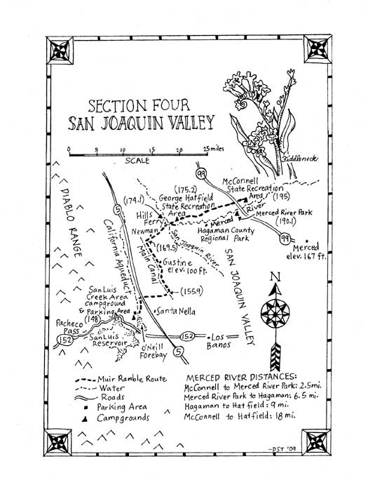
Section Four: San Joaquin Valley
Begin: San Luis Creek Recreation Area Campground, ONeill Forebay
End: McConnell State Park, Ballico
Distance: approximately 47 miles
Trip Information:
This section of the MRR crosses the San Joaquin Valley from the ONeill Forebay (west of Highway 5 near Santa Nella) to Ballico (east of Highway 99 on the Merced River). The route follows the California Aquaduct Bike Trail north to Newman then heads east to Hills Ferry where it crosses the San Joaquin River. It then continues east following a wiggling route of small roads just north of the Merced River until it passes under Highway 99 to end on the Merced near the town of Ballico.
In 1868 Muir described the San Joaquin Valley as one vast plain divided by two rivers, the Merced and the San Joaquin. Today it is a rural farmland defined by its borders to the west and east: Highway 5 and Highway 99. In 1868 there were no dams in the foothills. Both rivers ran free and annually flooded the vast empty landscape. The Swamp Act of 1850 decreed that a man could claim all the swampland he could survey from a boat, and local legend has it that rancher Henry Miller put a boat on a wagon and after a heavy winters rain claimed most of the "West Side" of the San Joaquin Valley. In 1870 this same Miller, needing irrigation water for his newly acquired farmland, built the first canal across the valley, from present day Millerton Reservoir to Crow's Landing, about 100 miles north. Then known as the Miller-Lux Canal and now called the Main Canal, it was completed in 1880. Today, with both rivers dammed and irrigated by Millers water, the San Joaquin Valley is covered with tiny towns, small dairy farms, great fields of grain and vast orchards of fruit and nut trees. It is crisscrossed by little roads and irrigation canals. It is lightly populated, mostly agricultural, and mostly flat, so a great place to ride a bike, and the MRR often follows these roads and canals to cross the valley.
Recommended trip: Begin: San Luis Creek Recreation Area Campground, ONeill Forebay End: McConnell State Park, Ballico Distance: approximately 47 miles We have both walked and cycled this section and currently recommend taking this section as a bike trip. We say currently because legal lodging isnt available spaced at a reasonable days walk. As a bike trip it can easily be done in two days. We recommend spending the night before you start the trip at the San Luis Creek Campground. The next morning start by following the California Aqueducts bike trail. The aqueduct is a stark cement waterway, and the bike trail is not much more picturesque, but it is elevated thus provides expansive long views over the fields of the flat San Joaquin Valley. Leave the bikeway just after passing Newman and follow rural roads to cross the Merced River at Hills Ferry, the actual spot where Muir crossed in 1868. End the day with a swim in the Merced River before setting up camp at Hatfield Recreation Area. The next morning, continue across the valley following canals and small streets past almond orchards, fields of grain and small dairies where curious Holstein cows line up along the fences to watch you pass. After crossing under Highway 99, end the day at the McConnell State Recreation Area where you can take another swim in the Merced River and then set up camp or return home.
Recommended Side Trip: In 1876 Muir floated down the Sacramento River on a raft he christened snag and in 1877 Muir floated down the Merced River: "I built a little unpretentious successor to out of some gnarled, sun-twisted fencing, launched it in the Merced opposite the village [Hopeton], and rowed down into the San Joaquin--thence down the San Joaquin past Stockton and through the tule region into the bay near Martinez. There I abandoned my boat and set off cross lots for Mount Diablo, spent a night on the summit, and walked the next day into Oakland. " footnote 1 If you want take a side trip in Muir's footsteps, well, really in his paddle strokes you can take an 18 mile raft trip down the Merced River from McConnell State Park to the Hatfield Recreation Area. The Merced River is now dammed upstream. It can be quite shallow and usually runs very slowly, about a mile an hour in late spring. At McConnell Park you can find a simple map with rafting instructions and floating distances. We took the trip in a small rubber raft, but suggest using a canoe or kayak to make the trip quicker and more pleasant. The river corridor is completely undeveloped and wonderfully natural, with many different species of birds and fish (a horned owl even flew close over our head as we floated by its roost). There are places to pull out or camp along the river, including the Merced River Campground at mile 2.5 and Hagaman County Park at mile 9. The trip can be done as a loop, leaving your raft at McConnell, parking your shuttle vehicle at Hatfield, then riding your bike back to McConnell, and floating back to the shuttle vehicle. The 18 mile trip could take all day or more, and the bike ride back a few hours, so plan accordingly.
What you need and need to know: Street maps: AAA California Regional Series map: Gold Country Accommodations: There are four campgrounds on the route, and only one hotel in the whole area that is directly on the route. See end of section for addresses. Canals and Access Roads: The MRR follows canals managed by three different irrigation districts, each with different policies, and these may change without notice. You will need to contact them before your trip to be sure the canal maintenance roads are open to the public. At the end of this section you will find information for contacting the irrigation districts. You will see signs on the canal access roads that say "Authorized Vehicles Only" so dont drive your car on them. Please be considerate: do not stray off the roads. The land on either side is often private property, and because of vandalism and theft, some access roads have been closed. If you get to a locked gate or a "No Trespassing" sign just use the other side of the canal, or a nearby street. Bicycles: If you are cycling we recommend fat tires; ride a hybrid or mountain bike. The surfaces of the access roads are dirt and change with the passing seasons. When it makes a difference, we will recommend which side of the canal to ride on, but you will have to keep your eyes open and make your own decisions. Remember the whole trip can also be taken on the county roads that parallel the canal maintenance roads.
Resources for Section Four: Transportation: THE BUS - Merced County Transit 880 Thornton Road Merced, CA 95340 www.mercedthebus.com Merced Taxi 301 W 18th St. Merced, CA 95340 (209) 722-8294 Accommodations: George J. Hatfield State Recreation Area 4394 North Kelly Road Hilmar, CA (209) 632-1852 www.parks.ca.gov Hagaman County Park 19914 River Road Stevinson, CA 95374 www.countyofmerced.com Merced River Resort 7765 Campground Road Delhi, CA 93315 (209) 634-6056 properties.camping.com/merced-river-rv-resort McConnell State Recreation Area 8800 McConnell Road Ballico, CA 95303 (209) 394-7755 www.parks.ca.gov/ Canal road access: Turlock Irrigation District 333 East Canal Drive Turlock, CA 95380 (209) 883-8222 www.tid.org Merced Irrigation District 744 W 20th St. Merced, CA 95340 (209) 722-5761 www.mercedid.com Central California Irrigation District 1335 W I St. Los Banos, CA 93635 (209) 209-826-1421 www.ccidwater.org Book: Ghost Towns of Merced County By Herb Wood Merced County Historical Society, 2005.
Section Four Trailhead Information: Beginning Trailhead: Access by car: The entrance for the San Luis Creek Recreation Area is near the bottom of the pass, about 6 miles west of Highway 5, and 10 miles east of Dinosaur Point Rd. Turn east and follow the entrance road. Go .4 miles to an entrance kiosk. Go .5 miles. Turn left at the sign for San Luis Creek Camping. Go 2.1 miles to the campground and day use parking area. Access by Public Transportation: Merced County Dial a Ride provides bus service from Livingston to Hilmar (TSA3), Hilmar to Gustine (TSA 10), Gustine to Santa Nella (TSA 4). Each route makes 3 trips per day. Ending Trailhead: Access by car: Exit Highway 99 on Collier Road. Go east .2 miles. Turn left on Canal Dr. Go 1.2 miles. Stay right on South Ave. Go 1.3 miles. Turn right on Pepper Street. Go .5 miles. Turn left on 2nd Ave. South. Go .5 miles. Turn right on McConnell Road. Go .2 miles, to the entrance for McConnell State Park. Access by Public Transportation: Merced Taxi. Recommended Trip Trailhead information: Same as above. Recommended Side Trip Trailhead Information: Beginning Trailhead. MRR mile 195.0 Ending Trailhead. MRR mile 175.2
Section Four Directions:
(148.0) Leave the campground or parking lot. Go .1 mile, heading east, towards the water, turn left and follow the paved path along the shoreline.
(148.1) Go through the bike/pedestrian access gate/stile in the chain link fence and follow the service road on the west side of the California Aqueduct. Go .9 miles.
Note: This is beginning of the California Aqueduct Bikeway (CAB).
(149.0) Cross over the McCabe Road Bridge. Go 2.6 miles following the bikeway on the east side of the Aqueduct.
(151.6) Turn right and exit the bikeway on Butts Rd. Go 1.8 miles.
Note: If you would rather, you can continue on the CAB all the way to Stuhr Road, west of Newman and connect with the MRR at mile 169.5.
(153.4) Turn left on Whitworth Road. Go .5 miles.
(153.9) Turn right on Bunker Road. Go 2 miles, passing an unmarked canal and crossing Highway 33.
(155.9) Cross over the canal and turn left on the service road of the unmarked Main Canal (managed by the Central California Irrigation District). If you get to Ingomar Road, you have gone too far. Go 5.7 miles following the canal as it generally winds its way north.
Note: The Main canal is the old Miller-Lux Canal. Check with CCID for current access policies.
(161.6) Cross over Highway 33 as the canal runs under the highway just south of Gustine. Go 7.9 miles following the east side of the canal crossing several unmarked streets and private driveways as the canal winds northwards, passing the town of Newman in the distance to the east.
Note: If you turn right on Highway 33, in .3 miles you will come to Gustine, with many places to get food. You can rest in the shade of Henry Miller Park at the center of town (follow 7th Street north to 3rd Avenue.) You dont have to backtrack; you can get to the canal by heading north on Sixth Street. When it ends, turn left on North Avenue/Fentem Road. Go 1 mile and you will reach the canal and the MMR at approximately mile 162.6. Turn right.
(169.5) Leave the canal and turn right (east) on Stuhr Road. Go 1 mile.
Note: The street sign for Stuhr is on the west side of the canal, and there is a white concrete water valve box stenciled with the word cemetery on the east side of the canal. Be careful on Stuhr, and watch for fast-traveling cars that may not be expecting pedestrians or cyclists.
(170.5) Cross Highway 33. Go 2 miles.
Note: To the right is The Hamlet Motel, the only motel directly on the route. It has clean reasonably-priced rooms.
(172.5) Stuhr Rd. ends. Turn left on unmarked Hills Ferry Road. Go 1.6 miles.
Note: This is a busy road with narrow or non-existent shoulders, so be very careful.
(174.1) Cross the San Joaquin River on a bridge. Go 1 mile.
Note: Hills Ferry, where Muir crossed in 1868, was a few hundred yards downstream.
(175.1) Stay left at the old arched metal fishing bridge. Hills Ferry Road becomes Kelley Road, as River Road heads off to the right. Go .1 mile.
(175.2) George Hatfield State Recreation Area is on the right. Go 1.5 miles.
Note: Spend the night at Hatfield if you are taking the recommended trip. The Merced River wraps around the park, and you will feel miles away from cities and highways as you swim in the river. There are beautiful camping and picnic areas nestled under mature shade trees. Locals call it Mosquito Park, so be prepared at dusk.
(176.7) Turn right on Turner Road. Go .3 miles. (It becomes Mitchell Road at a sharp left.)
(177.0) Turn right on Swensen Road. Go 1 mile.
(178.0) Swensen dead-ends. Turn right on Faith Home Road. Go .2 miles, until it dead-ends at Turner Rd.
(178.2) Turn left onto the service road for the Stevinson Canal, which parallels Turner Rd. Go 2.1 miles.
Note: For current canal access status contact the Turlock Irrigation District (TID). The service road is sand and dirt. If you are cycling and would rather ride on pavement, you can follow an alternate route:
Continue on Turner Road and go 3 miles. Turn left on Columbus and go 1.7 miles. Turn right on Geer and go 3.5 miles. Geer becomes Randolph Road, go .5 miles. Turn right on Bloss Ave. and go 2.5 miles. Turn left on Sycamore Street and connect with the MRR at mile 190.0.
(180.3) The canal veers north, and forks. Stay right, following the east fork, which is Lateral No 8. Go 4.7 miles.
(180.3) The canal veers north, and forks. Cross to the east side of the canal. Stay right, following the east fork, which is Lateral No. 8. Go 1.6 miles. (181.9) The canal makes a 90 degree left. Go .3 miles (182.2) The canal makes a hard right. Go .3 miles. (182.5) Cross Lander Ave. Go 2.5 miles.
(185.0) At a 90-degree right turn, the canal changes its name to the Highline Canal. Go 1 mile.
(186.0) The right (south) canal road merges with an unmarked city street, Williams Avenue. Go .5 miles to Griffith Rd.
(186.5) Cross Griffith Rd. Go 1 mile, following the northern service road to Merced Ave. (The south road is closed.)
(187.5) Cross Merced Avenue, turn left and then continue on the south service road. Go 2.6 miles, crossing Hinton Ave.
Note: The orchards here are peaches, and the canal road is surfaced with pits!
(190.1) Turn right on Bloss Ave. Go .6 miles. Bloss becomes Collier Rd. at the intersection with Campground Rd.
Note: Campground Rd. leads to the Merced River Resort, a private campground with river access, showers and full hookups.
Warning: There is no shoulder on Bloss and 16 wheelers use it regularly, so be careful.
(190.7) Continue on Collier. Go .6 miles, passing under Highway 99.
(191.3) Turn left on Canal Dr. Go 1.2 miles.
Note: In .5 miles you will come to again to the Highline Canal as it runs parallel to Canal Rd. This is still a TID canal.
(192.5) Turn right on South Ave. Go 1.3 miles.
Note: The canal turns left in 1 mile. Leave it and follow South Ave. for .3 miles.
(193.8) Turn right on Pepper Street. You will see a sign for McConnell State Recreation Area. Go .5 miles.
(194.3) Turn left. Pepper becomes Second Ave. Go .5 miles.
(194.8) Turn right. Second Ave. becomes McConnell Rd. Go .2 miles, to the entrance for McConnell State Park.
(195.0) End at McConnell State Park. There is a day use or camping fee.
Note: This is the end of this section and the recommended trip. McConnell State Park is a 74-acre recreation area, the first state park in the San Joaquin Valley, opened in 1950. It is named after Thomas McConnell, a sheep rancher and pioneer who homesteaded here in 1871.
The park sits on the banks of the Merced River, and four miles upstream is an ancient village site that belonged to the Northern Valley Yokuts. There are picnic, camping and play areas in the shade of mature cottonwood and sycamore trees. A short path leads to a sandy beach with swimming hole in the river, where visitors swim, or fish for catfish, black bass and perch. You can end trip with a cool swim in the river, then take a hot shower back in the campground (bring quarters).