Directions for following the Muir Ramble Route
Section Five
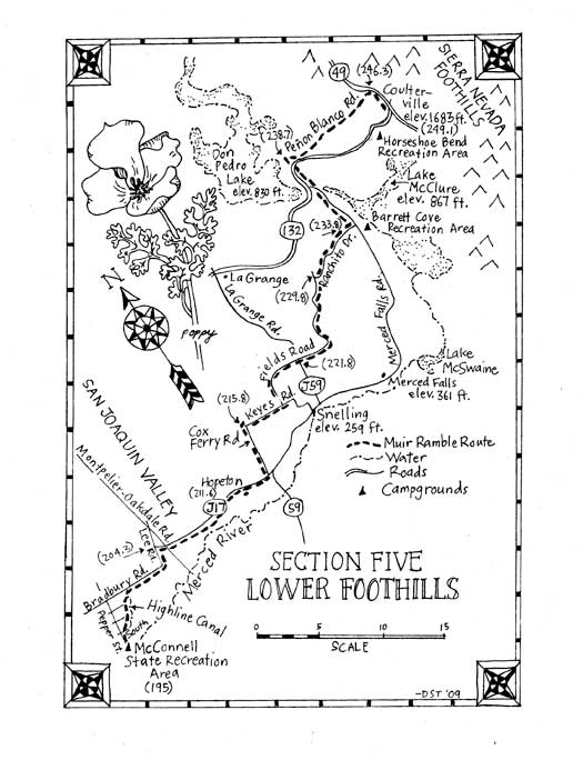
Section Five: The Lower Foothills
Begin: McConnell State Park, Ballico
End: Coulterville
Distance: approximately 54 miles
Trip Information:
Section five of the MRR begins near the eastern edge of the San Joaquin Valley at about sea level. The route passes through the lower foothills and the surrounding vegetation changes gradually with the elevation gain. The trip begins following little roads past big almond orchards. The narrow lanes become rural truck routes as the route passes Hopeton and the vineyards that border the Merced River. Near Snelling the route used to follow Fields Road through vast pastoral grasslands speckled with wildflowers in vernal pools and dotted with huge valley oaks, but the land is now in private hands, so a reroute is noted below. As the route circles Don Pedro Lake it gently climbs through now divided ranch land, past oak and wildflower covered hills with tombstone rocks cropping up through the tall grass. Beyond the lake the terrain becomes more steep and brushy ceanothus, scrub oak and gray pine begin to appear. Just below Coulterville at 1680 feet elevation, tall ponderosa pines begin to scent the air.
Muir would still recognize the lower foothills: the landscape is still very rural, covered mostly by ranch and farmlands. But the region has not remained unchanged. Recently, relatively cheap land brought an invasion of commuters and exponential population growth without corresponding improvements to the countys infrastructure. The result has been that in many places there are too many cars, traveling fast, on narrow roads with narrow or non-existent shoulders. Nevertheless we had a great adventure walking through there in 2006. But given the road situation and the fact that legal lodging isnt spaced at a reasonable days walk we cant recommend it as being very safe or fun, at least not yet.
We can however recommend the entire section as a bike trip for the strong experienced street-savvy cyclist. It can be done leisurely in two 26-mile days, spending the first night at McConnell, the second at Barrett Cove Campground on Lake McClure and the third in Coulterville.
What you need and need to know: Street maps: AAA Sectional Series: Central California, AAA Regional Series: Gold Country Accommodations: Hotels: In Coulterville there is the Hotel Jeffery, which provided lodging and meals when Muir passed through in 1868. Camping: There is a campground at Barrett Cove on Lake McClure and an RV campground in Greeley Hill. Resources For Section Five: Accommodation: Camping info for Barrett Cove: Merced Irrigation District Parks Department /Campground Information 9090 Lake McClure Road Snelling, CA 95369 (209) 354-2955 www.lakemcclure.com Yosemite Westlake Campground 6554 Greeley Hill Road Coulterville, CA 95311 (209)878-3847 www.www.yosemite.com/lodging/camping/ Hotel Jeffery 1 Main St Coulterville, CA 95311 (209) 878-3471 www.hoteljefferygold.com Side trips: County Courthouse Museum. 21st and N Streets, Merced, CA 95340 (209) 723-2401 www.mercedmuseum.org Canal road access: Merced Irrigation District 744 W 20th St Merced, CA 95340 (209) 722-5761 www.mercedid.com
Section Five Trailhead Information: Beginning Trailhead: Access by car: Exit Highway 99 on Collier Road. Go east .2 miles. Turn left on Canal Dr. Go 1.2 miles. Stay right on South Ave. Go 1.3 miles. Turn right on Pepper Street. Go .5 miles. Turn left on 2nd Ave. South. Go .5 miles. Turn right on McConnell Road. Go .2 miles, to the entrance for McConnell State Park. Ending Trailhead: Access by Car: Follow State Highway 132 to the intersection with Highway 49 in Coulterville. Access by Public Transportation: Mariposa County has dial-a-ride service (Mari-Go) between Coulterville and Mariposa. It runs on a very limited schedule, but you may be able to work out something with them. In the future, we hope more busses may run in Mariposa County. Sierra Taxi also runs a 24-hour taxi service.
Section Five Directions:
(195.0) Leave McConnell State Park on McConnell Rd. Go .2 miles.
(195.2) Turn left on Second Ave. Go .5 miles.
(195.7) Turn right on Pepper Street. Go .5 miles.
(196.2) Turn left (west) on South Ave. Go .1 mile
(196.3) Turn right on the Highline Canal maintenance road. Go 1.7 miles, crossing two streets, to Bradbury Road.
(198.0) Turn right (east) on Bradbury Rd. Go 1.1 miles.
(199.1) Turn left on Ballico Road. Go .2 miles, continuing until you cross the railroad tracks.
(199.3) Turn right on Santa Fe Drive. Go .4 miles.
(199.7) Make a slight left on Bradbury Rd. Go 2.6 miles.
(202.3) Turn left on Lee Rd. Go 2 miles.
(204.3) Turn right on West Turlock Rd. (County Road J17). Go 7.4 miles.
Note: The Turlock Road was first a wagon trail between Turlock and Snelling. It is now a busy road, used by big trucks, so be careful. 3.7 miles from Lee Road, there is an irrigation canal on your left. This is the Northside Canal, and it leads directly to Cox Ferry Road at MRR mile 214.7. The Northside Canal is managed by the Merced Irrigation District and they currently do not allow the public to use the maintenance roads for exercise or pleasure. Contact MID to ask if this has changed, and if not, make a request that they reconsider their policy.
(211.7) Pass the almost abandoned town of Hopeton. Go 1.2 miles.
Note: Muir settled near Hopeton during the summer after his 1868 trip to Yosemite, and some of his letters were mailed from its post office. At the time Hopeton was an active port on the Merced River, but after the railroad was built, and the water from the river was diverted for irrigation, river navigation became impossible and the town was deserted. Now all that remains is one house, a church and the Hopeton Elementary School. Before 1866, Hopeton had been called Forlorn Hope, perhaps because of its lack of success in gold mining, but perhaps with a premonition of its future. This is near the area that John Muir called Twenty Hill Hollow, where he lived as a shepherd in the winter of 1868-9. The next summer he took the sheep to high pasture in Yosemite as recorded in his book My First Summer in the Sierra.
(212.8) Turn left on Highway 59. Go 4.7 miles. Unfortunately Fields Road is now closed to the public so we have rerouted the MRR. You must travel along busy Hwy 59 through the small town of Snelling. The huge piles of river rock beside the roads and bordering the river are remnants of massive gold dredging operations from early 20th century. If you want to learn more about this countys history and see old maps of the region, we suggest you take a side trip to Merced and visit the County Courthouse Museum.
(217.3) Turn left on Merced Falls Road. Go 14.4 miles.
Warning: Merced Falls Road is a main thoroughfare and cars are driving fast, so be extra cautious.
(231.7) Turn right into Barrett Cove Recreation area. Go 1 mile.
(232.7) Turn left on Piney Creek Road. Go 2.3 miles.
(235) Turn right on Merced Falls Road. Go 1.6 miles.
(236.6) Turn right on Castillo Way. Go .9 mile.
(237.5) Turn left on Arbolada Dr. Go .2 mile crossing Highway 132.
(237.7) Turn right on Abeto St. Go .3 miles.
(238.) Turn right on Enebro Way. Go .2 mile.
(238.2) Turn left on Highway 132. Go .1 mile.
Note: This is a very busy road; use caution.
(238.3) Turn left on Granite Springs Road (this is also signed Moccasin via Marshes Flat Road and on some maps is Lozano St.). Go .9 mile.
(239.2) Turn right to stay on Granite Springs Road (the bigger road that continues straight ahead is Lozano St.) Go 2.2 miles.
(241.4) Turn left on Penon Blanco Road. Go 4.5 miles.
Note: Locals say that Muir followed Penon Blanco with the sheep in 1869. As you descend the hill, looking north-east you can see the white quartz outcropping that gave Penon Blanco its name.
(245.9) Penon Blanco Rd. ends. Turn right (south) on Highway 49 towards Coulterville. Go 2.8 miles.
Note: This is also a very busy road; use caution.
(248.7) End at the intersection of highways 49 and J132 (aka Greeley Hill Road and Main Street) in Coulterville.
Note: On your left is the Hotel Jeffery, a great place to stay, as Hotel Jeffery was providing lodging when Muir walked through in 1868.