
Directions for following the Muir Ramble Route
Section Seven
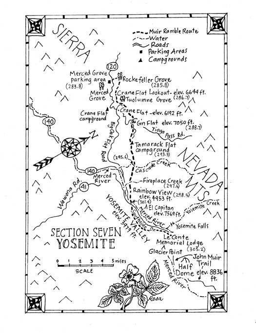
Section Seven: Yosemite
Begin: Yosemites Merced Grove Trailhead
End: Yosemite Conservation Heritage Center, Yosemite Valley
Distance: 21 miles
Trip Information:
Section seven of the MRR follows little used trails from Crane Flat to the Yosemite Valley floor, closely tracing the actual route Muir used in 1868. The trip starts at the Merced Grove trailhead then follows an abandoned dirt road through the Rockefeller Groves many magnificent old growth giant sugar pines. The route climbs past the Crane Flat fire lookout then drops back down to Crane Flat near the Tuolumne Grove. From there the route runs parallel to the Tioga Road following Gin Flat Road. This dirt road, now closed to vehicular traffic, provided access to Tuolumne Meadows before the current Tioga Road was built. In 1868 it was the route of the Coulterville Free Trail, which Muir followed. At Gin Flat the MRR crosses the Tioga Rd. and follows a paved remnant of the Big Oak Flat Road, which here followed the route of the Coulterville Free Trail down to the Tamarack Flat Campground.
Once through the campground, the road is closed to vehicular traffic but continues as a trail. This is where Muir said that because of snow he lost the trail but found it again near the brow of the valley. The descent into Yosemite Valley is stupendous, dramatic and strenuous. The trail is high on the north wall, directly opposite the Bridalveil Fall to the west of El Capitans broad face, so for most people the views of the valley will be new and wonderful. You will have to scramble across talus fields filled with boulders the size of refrigerators but the opportunity to see El Capitan, Half Dome and Bridalveil Fall from this new vantage point will make it worthwhile. The MRR reaches the valley floor near the base of El Capitan. You can end the trip there or continue on trails past Camp Four, Yosemite Falls and Yosemite Village, to the Yosemite Conservation Heritage Center, the Sierra Clubs home in the Yosemite Valley. This is the official ending place for the MRR.
Recommended Trip:
Begin: Yosemites Merced Grove Trailhead
End: Yosemite Conservation Heritage Center, Yosemite Valley
Distance: 21 miles
The recommended trip encompasses the whole section and can be done as a two-day backpack trip. Day one is a 9.5-mile hike. If you leave the Merced Grove trailhead by mid-morning you will be able to reach Tamarack Flat with sufficient time to set up camp before dark. Day two is an 11-mile hike that will take a full day. We have hiked this section of the MRR several times now and it has always proved an enticingly beautiful trip through the little known sugar pine and oak ecosystems. The best time of year for the trip is late spring. If you leave after the snow has melted, but before the Tioga Road opens, there won't be any cars on the road and you will have the whole Tamarack Flat campground to yourself! But be prepared to spend a day slogging through slushy snow at the higher altitudes near Gin Flat. This trip will require having two vehicles, except in the summer months when you can use the Yosemite Area Regional Transportation System. If you want to cut four miles off the second day you can park your shuttle vehicle at the climbers parking area near MRR mile 301.2.
What you need and need to know: Street maps: AAA Recreation Series: Sierra Nevada Yosemite Area
Topographic Maps: Tom Harrison Maps: Yosemite National Park
Accommodations:
Hotels: There are no hotels on the route until you reach the Yosemite Valley where there are many options.
Camping: There are campgrounds in Yosemite, and the ones on the MRR are described in the text. If you plan to camp outside of a campground you will need a wilderness camping permit, acquired at a Yosemite Wilderness Permit Station, either at the Big Oak Flat entrance station or the Valley Visitor Center. Wilderness camping is not allowed within 1 mile of a road or trailhead. Study and follow all the camping regulations that come with the permit.
Bicycles:
Wheeled vehicles of any kind are not allowed on trails in Yosemite National Park. This section cannot be done on a bike as all of the non-paved trails the MRR follows are considered trails.
Water:
All stream water will need to be purified before drinking. Make sure your water filter or water purifying tablets are rated to deal with giardia lamblia and cryptosporidium. There is water at the Crane Flat Lookout, but the water is not guaranteed potable and you will need to purify it. There is also water at Crane Flat Gas Station and NatureBridge, and the next source is Tamarack Creek, 7.5 miles away.
Warnings:
In spring the creeks will be cold and in places will be flooding over the trail. Be careful when walking through fast moving water.
If you leave a car parked anywhere in Yosemite National Park, or when camping, you are required to store all your food and scented items (like lip balm) in bear boxes or bear-proof canisters. Bear canisters can be rented from the wilderness office. Bear boxes are located at many trailheads. Resources For Section Seven: Maps:
Tom Harrison Maps
2 Falmouth Cove
San Rafael CA 94901
(800) 265-9090 or (415) 456-7940
www.tomharrisonmaps.com
Transportation:
YARTS (Yosemite Area Regional Transportation System)
1-877-989-2787
www.YARTS.com
Accommodations:
Camping reservations in Yosemite:
(877) 444-6777
www.recreation.gov
Hotel reservations in Yosemite:
(866) 875-8456
www.nationalparkreservations.com/yosemite
Contacts:
Yosemite Conservation Heritage Center Curator
Bonnie Gisel
(209) 347-7300
Email: Bonnie.Gisel@sierraclub.org. Trailhead Information: Section Seven Directions:
Beginning Trailhead:
Access by Car: The Merced Grove trailhead is a turnout on the south side of Highway 120, 4.5 miles east of Yosemites Big Oak Flat entrance station.
Note: This is not a standard place for backpackers to leave a car so you will have to get instructions from a ranger at a wilderness permit station as to what you have to do. There are bear boxes and restrooms at the Merced Grove trailhead.
Access by Public Transportation: The Merced Grove Trailhead cannot be accessed by public transportation at this time, so it is easiest to do the trip with a two car shuttle system, leaving one at the beginning trailhead and the other at the ending trail head, spending the nights before and after the trip at any of the campgrounds or hotels in the valley, which can easily be reached from the ending trailhead using the free Yosemite Valley Shuttle System.
Ending Trailhead:
Access by Car: Follow road signs towards Curry Village. The Yosemite Conservation Heritage Center is on Southside Dr., across the street from Housekeeping, at shuttle bus stop #12.
Note: You cannot park overnight in the Heritage Center parking lot, but there is a backpackers parking lot near Curry Village. You will need a permit, acquired from one of the wilderness permit stations, to leave your car there overnight.
Access by Public Transportation: YARTS, and Yosemite Valley shuttle bus
Alternate Ending Trailhead: If you want to cut a few miles off the end of the trip, you can park one shuttle vehicle at the El Capitan climbers parking area, (near MRR mile 303) which is just east of the junction of the El Capitan Cutoff and Northside Drive. There are bear boxes on the side of the road, and the Valley Shuttle Bus will take you here too.
Trailhead For Recommended Trip:
Same as above
Shuttling suggestion:
If you are walking or only have one car, from June through September you can use the Yosemite Area Regional Transportation System (YARTS), the Tuolumne Meadows Tour Bus to get from the Valley to Crane Flat. They all leave from the Valley Visitor Center.
You then have several options. You could walk from Crane Flat .2 mile east on the Tioga Road/Highway 120 and join the MRR at mile 288.1, or you could walk .2 mile west on Highway 120 to the Crane Flat campground. If it is late you could sleep there for an early start the next morning. The road to the Crane Flat fire lookout is across the highway and .4 mile west of the campground entrance. You can walk 1.4 miles up the Lookout Road to visit the lookout and to continue on the Ramble at MRR mile 286.8.
(283.8) Leave the Merced Grove Trailhead heading west on Highway 120 (back towards the entrance), walk a few yards, cross the highway, climb over (283.8) Leave the Merced Grove Trailhead heading west on Highway 120 (back towards the entrance), walk a few yards, cross the highway, climb over, or around, a gate blocking a dirt road that heads north. Go 2 miles, following the dirt road up the hill.
Note: This is the Rockefeller Grove Trail. It is also used as a winter ski route and occasionally you will find it marked with yellow or orange metal tags nailed to tree trunks about 10 feet from the ground. The road follows an old railroad bed and passes through the Rockefeller Grove of giant sugar pines. This grove is not a compact group of trees like the Merced Groves Sequoias. It has many magnificent trees spread out over a great area.
(285.8) Turn right (east) on a faint trail that leads southeasterly to the Crane Flat Fire Lookout. Go .1 mile.
Note: If the road ends you have gone .2 miles too far. We suggest you take this as a detour because this .2 miles is lined by many of the groves giant sugar pines. The trail to the lookout is partially marked as a ski trail with some fluorescent plastic tape markers tied to tree branches.
(285.9) Turn right at the next Y. Go .8 miles, heading uphill in a southeast direction, following pink and orange plastic ribbons tied to tree branches that mark a ski trail, skirting around a prescribed burn area, looking for the trail that rings the Crane Flat lookout tower.
Note: This right fork of the Y appears totally blocked with downed trees, and quite faint.
(286.7) Turn left on the ring trail. Go .1 mile.
Note: The paved area beside the lookout is used by emergency and fire fighting vehicles. It is all off limits and should never be walked across. To visit the Crane Flat Fire Lookout, take a detour and turn right. Go .1 mile. Turn left on the path up to the lookout. The old lookout building is no longer used for fire fighting purposes, and visitors are welcome. There are stunning 360-degree views from its walkways and inside the building there are panoramic photographs captioned with the names of all the peaks. There are restrooms and water near the lookout, but the water is not guaranteed potable and you will need to purify it. The next water is at Tamarack Creek, 7 miles away.
(286.8) Turn right. Go .7 miles, crossing the parking lot and following the unsigned paved road down the hill.
Note: If you go 1.5 miles down this road you will come to Highway 120 and a walking entrance to the Crane Flat Campground.
(287.5) Turn left on a dirt road (marked as a ski trail #2, with yellow metal ski trail marker flags nailed about 15 feet up the trees.) Go .5 miles.
(288.0) Turn right on the service road coming from the Tuolumne Grove parking lot. Go 50 feet.
Note: If you continue straight ahead you will find the trail to the Tuolumne Grove on your left. A side trip to see these giant trees will add an extra 2 miles (round trip) to your hike. There are about twenty-five giant trees in the grove, including the famous tunnel tree. In days gone by, cars following the Big Oak Flat Road could drive right through this tree.
(288.0) Turn right on a dirt road that parallels the Tioga Rd. Go .1 mile, until the road sweeps to the right, then cut left, down the embankment and cross the Tioga Rd.
(288.1) Enter the meadow. Go about 300 feet, walking cross-country along the southern edge of this meadow, looking on the right for a yellow ski trail flag on a tree.
Note: Please be careful not to damage the meadow. If it seems too marshy, as it can be in early spring after a wet winter, walk up the Tioga Road. Go .6 miles, passing NatureBridge on the left and meeting the MRR at Gin Flat Road (MRR mile 288.7).
(288.2) Turn right. Go .1 mile, following the flags through the trees to a clearing.
(288.3) Turn left. Go .1 mile, generally eastward, following the flags along this clearing heading to the edge of a big meadow.
(288.4) Turn left. Go .1 mile, following the flags around the west side of this meadow, staying left of the rocks and right of the next tree with a flag.
(288.5) Enter the trees again. Go .2 miles, following flags up to the Tioga Rd.
(288.7) Turn right, go 50 feet, cross the road onto an unsigned dirt road. Go 1.8 miles north on ski trail #3 until you once again come to the Tioga Rd.
Note: This is Gin Flat Road, called Gentry's Road by some old-timers. Before the Tioga Road was in place, this was the route of the Old Big Oak Flat Road, and before that of the Coulterville Free Trail. It climbs through a mixed conifer forest and in 1.7 miles passes the high point of entire MMR on a rocky knoll at about 7060 feet.
(290.5) Cross the Tioga Road. Go 2.8 miles, following the Tamarack Flat Road to the campground.
Note: This is where Muir lost the trail in the snow. If snow is obscuring the paved road, study your maps and geological features carefully. We found it helpful to look up towards the treetops, to find the clearings that indicated the path of the road. This road is also the Old Big Oak Flat Road. It was used as the northern entrance to the valley from 1874 until it was replaced in 1940 by the lower Big Oak Flat Road that is currently in use.
(293.3) Pass through the campground. Go .1 mile.
Note: The Tamarack Flat campground is a good place to spend the night. If it is still closed for the winter, you will need wilderness permit. There are bear boxes and outhouses, but the only water is from the creek, which must be purified before drinking. If Tamarack Creek is flooding the road, cross upstream on a log.
(293.4) Climb over the locked gate. Go 1.8 miles, following the unmaintained continuation of the Old Big Oak Flat Road.
Note: The sign posted here states that El Capitan is 8.4 miles and Yosemite Valley is 16.2 miles. The MRR follows a different route to the valley. It is only 8 miles from here to the valley floor near the base of El Capitan, but they are going to be hard miles!
(295.2) Cross a fork of Cascade Creek. Go .2 miles.
Note: If the trail is flooded cross on a big log just upstream.
(295.4) Pass the Foresta Trail leading to the Big Oak Flat Road on the right. Go .2 miles.
(295.6) Cross Cascade Creek on an old wooden bridge. Go .5 miles.
Note: There are deep swimming holes hidden from view upstream and a nice campsite on the east side of the creek.
(296.1) Pass the trail to El Capitan on the left. Go 1.5 miles.
Note: Past this point you will encounter downed trees blocking the road and several big rockslides. In .3 miles you will pass the spot where Colonel E. S. Gentry built a saw mill and stage stop on the brink of the cliffs overlooking the Merced River Canyon that served as the last stage stop before reaching the valley. In 1868, just below Gentrys was Oh My! Point, which gave travelers their first majestic view of Yosemite Valley.
(297.6) Cross Fireplace Creek. Go .9 miles.
Note: The creek has eroded away the road, but it is usually possible to wade through. In a dry year this will be the last water before reaching Ribbon Creek, over 3 hard miles ahead.
(298.5) Pass an old scenic view site on your right. Go .1 miles.
Note: This breathtaking vista is called Rainbow View. There is an old metal railing there to keep visitors, distracted by the stunning view of Bridalveil Fall, from tumbling over the precipice.
(298.6) The road ends in a field of boulders. Go .3 miles.
Note: Directly ahead is a remnant of rock retaining wall, part of a series of switchbacks on the Old Big Oak Flat Road called the "Zigzags". Below that rock wall is a clump of trees. The old road continues just below those trees. Traverse diagonally towards the trees then circle around them to the northeast. Dont get below the trees or you will miss the road, and you cannot see it when you are looking uphill. Never travel directly above another hiker on a talus field. Be careful not to push boulders that could start a rockslide!
(298.9) Continue on the intermittent road down towards the valley. Go 1.2 miles, finally passing through the wood lot where the park service stores and cuts firewood for use at campfire programs.
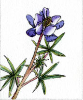
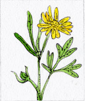
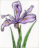
Note: As you lose elevation, the views of Yosemite Valley grow in grandeur. El Capitan comes into view and Half Dome looms in the background. Bridalveil Fall is directly across the Valley and the pool above the fall can be seen spilling its contents over the brink. In spring you will find a profusion of wildflowers.
(300.1) When the road cuts back to the right, leave the road and continue straight on an unmarked trail crossing Ribbon Creek. Go 1 mile, skirting the base of the cliffs towards Yosemite Village.
Note: If you reach paved Northside Drive, you have missed the cutoff.
(301.1) Turn right on a wide dirt trail that climbers use to haul their gear between the base of El Capitan and their parked cars. Go .1 mile
(301.2) Turn left on Northside Drive. Go .2 miles.
Note: This is the location of the alternative trailhead at the parking area for El Capitan climbers.
(301.4) Veer right on El Capitan Crossover, the connector road between Northside and Southside Drive. Go .3 miles.
(301.7) Turn left on Southside Drive. Go .2 miles heading east
(301.9) Turn right, off the road on a connector trail that leads to the main trail around the Valley floor. Go .1 miles.
(302.0) Turn left on the main trail around the Valley floor. Go 3.2 miles.
(305.2) End at the Yosemite Conservation Heritage Center.
Note: The Yosemite Conservation Heritage Center is the Sierra Clubs home in the Yosemite Valley.