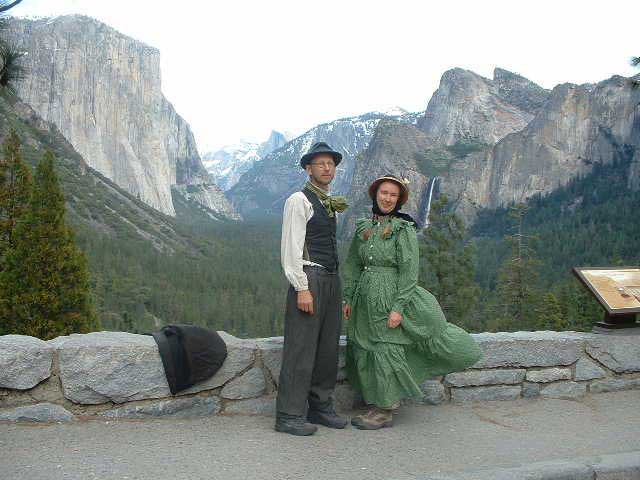
Peter and Donna Thomas' 2006 Route
I. Santa Cruz-San Francisco-Oakland
Day 2 Day 3
Day 4 Day
5
Day 6 Day 7
II. Santa Clara Valley (Day 8 through 10)
III. Pacheco
Pass
(Day 11 through 20)
IV. San Joaquin
Valley
(Day 21 and up)
VI. Yosemite
VII. Wawona
VIII. Return to Santa Cruz
Day 32 May 10
13.5 miles
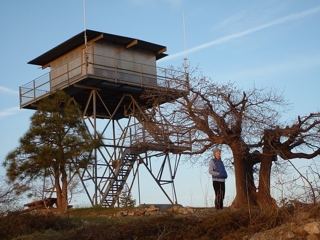
Pilot Peak Fire Lookout to Crane Flat
 We woke up to sunrise over the Sierra and the whole forest shining below us. We could see Kinsley Flat, looking small, way off to the southwest. A s the saying goes, we felt "on top of the world." Our goal for the day was to follow the old Coulterville Road into Yosemite National Park and then get to Crane Flat. We started walking early, as it was going to be hot. After about three miles we got to what Richard Ferry called five corners, ("well really, four corners plus one road that is a little before the junction.") When we got there it turned out to be five corners (plus that little road before the junction, making it six). We were not exactly sure which road to take; several signs were missing. We consulted the maps and made our best guess, but had not made our move for the road just yet. As we were standing there, a truck drove up the road on the left. We had not seen anyone for 24 hours, so it was like a miracle or just a way of the universe saying to us that we will be taken care of. The driver operated one of those masticator machines and was heading to work. He said he had come up the road from Highway 120, and he confirmed our choice. We spoke for awhile and looking at each other closer we then realized that we had been in neighboring campsites at the Yosemite Westlake Campground two days before. The big vast wilderness we were in got real small for a minute or two while we were there.
The road led to Hazel Green, where we walked by the old ranch house and stage stop. It was posted private property, but we could not find anyone to ask for permission to pass, and it seemed that since it had been a through road since the 1860s that we could probably continue to use it. When Muir and Chilwell used this road, only the Indians knew about the nearby Merced and Toulumne Groves of giant sequoias, and it went from Hazel Green more or less directly to Crane Flat. In the early 1870s, the wagon road surveyors came upon the Merced Grove, and the Coulterville Road was rerouted so travelers could see the trees (and the road investors might make a better profit on the toll road). It was this later Coulterville Road that we were following.
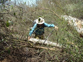 After Hazel Green there was a sign that said "Road closed ahead dew (sic) to brush". To the south we could see a barren landscape, most of the trees had burned in a 1980s fire. Through some miracle, Hazel Green had escaped the fire and it sat a green haven on the edge of a grey snag-studded expanse of chaparral. The road passed through the burnt landscape. It was rarely used. The roadbed was so hard that nothing could grow in it, but the brush grew thick on both sides and began to arch over the road so that we walked under a scraggly bower. The brush closed in on us and we pushed our way through it. The road became so choked up that we got down on hands and knees and crawled under it. The little tunnel under the brush went on and on. The sun blazed hot by this time but we could not turn back. What would we do? Go back to Highway 120 (a ten mile detour to have the pleasure of walking into Yosemite on a busy highway?) We crawled for about a mile. It felt like some epic adventure. The brush caught on our backpacks, yanked us backwards, then flew back in the face of the person who followed. There was the sound of brush breaking all around us and we figured Muir must have put this trap here to make our story sound a little more adventurous. We could stand up for a few minutes, but then had to get back on hands and knees. The brush began to thin and finally we reached open road again. We figure people have gone in from both directions, but the brush has stopped them, so the road is still good on both ends, but we could not see any trace of anyone having gone from end to end in years.
We went a little further on a good road, turned a corner and all at once we were back in the pines. It appeared that they had all dropped all their cones all at once. The road was littered with them and they acted like ball bearings as we skidded along. Just a little further up the road we came to a sign announcing we had entered Yosemite National Park. We celebrated our success by washing in a small stream and eating lunch.
Muir and Chilwell reported six feet of snow at Crane Flat. It was not long until we first reached our first snow, just patches off to the side. The road became damp, then wet, then a small river, as snowmelt filled it like a small stream. We came to Highway 120 at the Merced Grove trailhead and to avoid walking down the highway all the way to Crane Flat we walked just a few feet up the road to the trail that lead to the Rockefeller Grove of giant sugar pines. This road was really patched with snow and the day's hike now became a sort of triathlon, brush crawling, pine cone rolling and snow hopping. Now and then we came across traces of an older road that we suspect were the vestiges of Coulter's road Muir had followed.
About five hundred yards before the trail ended, we took a fork to the right that led to the Crane Flat Fire Lookout. We arrived there in the late afternoon and gazed back at the Pilot Peak Lookout we had left early that morning, a small dot on the horizon. We had a real sense of accomplishment seeing the distance we had covered and thinking of the challenges we had overcome. A few miles on a little-used road, from the lookout to Crane Flat, took us back to the Old Big Oak Flat Road at the Tuolumne Grove trailhead, and we camped on the road at the edge of the flat, now a snow-covered marsh.
designed by Julia van der Wyk © 2006