

Directions for following the Muir Ramble Route
Section Three
Click here to see a PDF with photographic maps of the Wildlife Areas
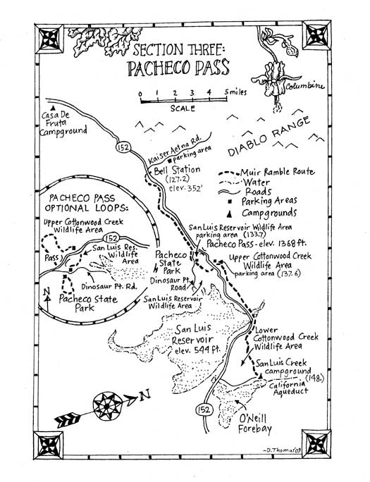
Section Three: Pacheco Pass
Begin: Bell Station
End: ONeill Forebay
Distance: 20.8 miles
Trip Information:
Section three of the MRR crosses the Diablo Range over the Pacheco Pass. It begins with no alternative but to follow Highway 152 to get up to the pass. It is a highway and not a freeway, so technically pedestrians are allowed on it, but it is a very busy and dangerous four-lane road. We searched for alternatives but there are none: the land on both sides of the highway is private. Perhaps some day there will be a pedestrian right-of-way using the fire roads that run beside the highway, but today the only safe way to get to the pass is by car.
From there the route heads down the eastern side of the Diablo Range following firebreaks and ranch roads through the San Luis Reservoir, Upper Cottonwood Creek and Lower Cottonwood Creek Wildlife Areas. These wildlife areas are managed by California Department of Fish and Game and primarily used during hunting season (autumn and winter), and are practically unused the rest of the year. Of all the places we have hiked, this is where we found it easiest to imagine we were still in Muirs 1868 California. In springtime there are literally seas of flowers. Keep your eyes open for tule elk. They are larger than deer, have a prominent white rump and travel in herds: a bull with up to thirty females and calves. It is estimated that before the gold rush there were half a million tule elk roaming the grasslands from the Sierra Nevada foothills to the coast. By Muirs day they were nearly gone, but were saved from extinction by cattleman Henry Miller who then owned millions of acres of land in California and Oregon including much of the land around the Pacheco Pass. Today it is estimated there are over 2,000 tule elk in herds found on 22 reserves between Tomales Bay and Bakersfield.
The section ends at the edge of the ONeill Forebay. This is a man made body of water is part of the San Luis Reservoir State Recreation Area and is used for boating, fishing and camping. The water comes from Sierra Nevada snowmelt and is pumped up to the San Luis Reservoir at night when energy is cheap then let down again to provide hydroelectricity when it is needed during the day.
Recommended Trip:
Begin: San Luis Reservoir Wildlife Area parking lot. (MRR mile 133.7)
End: San Luis Creek Recreation Area Campground. (MRR mile 148)
Distance: 14.3 miles.
The recommended trip is a 14.3 mile hike from the top of the pass to the ONeill Forebay. It wanders through Fish and Game wildlife preserves. The terrain is rough. The trails are often firebreaks that have been graded without hikers in mind. Overnight camping is not allowed so the trip has to be done as a day hike. It will be a long and hard day but it will have its rewards. There will be incredible opportunities to see wildflowers and wildlife, you will probably not see another person all day, and many parts will feel as if they have not changed since Muir walked through!
The trip begins hiking down and back up the ranch roads of the San Luis Reservoir Wildlife Area. The route then crosses Highway 152 and continues into the Lower Cottonwood Creek Wildlife Area. From MRR mile 141.2 to mile 142.6 there is no alterative but to walk on the wide shoulder of Highway 152. Walking beside a busy highway is dangerous. If you attempt this take all the proper precautions including traveling in good daylight, walking against traffic, wearing fluorescent clothing and staying as far from traffic as possible. The route ends at the San Luis Creek Recreation Area Campground on the ONeill Forebay. Alternative Trips:
We recommend two different day hikes loops from the pass that can be taken as alternatives to the challenging recommended trip. Both leave from MRR mile 133.7, and both will give you access to this relatively unknown and beautiful oak grassland.
Alternative Recommended Trip One: This is a very strenuous 13 mile loop hike that first follows the MMR through the San Luis Wildlife Area to the parking area at MRR mile 137.6 then loops back through the remote sections of the Upper Cottonwood Creek Wildlife Area. This wildlife area is incredibly beautiful, with miles of open oak grasslands and views of rolling hills in all directions. From one point you can see Mt. Hamilton to the northwest, Fremont Peak to the southwest, the San Luis Reservoir to the south and on a clear day, the Sierra Nevada to the east. It is also incredibly under-utilized and one of the places on the trip where it seemed John Muirs footprints were still fresh. The first part of this trip can be done as a 6.5 mile one way trip if you have a shuttle vehicle. Begin at the San Luis Wildlife Area parking lot on Dinosaur Point Road. Follow the MRR from mile 133.6 to mile 137.8. After you have passed through the gate of the second parking lot for the Upper Cottonwood Creek Wildlife Area turn left and head up the steep dirt road. Follow it along the ridgeline for a few miles heading towards the north boundary of the wildlife area. At the boundary veer left, following the road for a couple more miles west, dropping down to a spring and then back up. When you reach a substantial north-south running ranch road (Fifield Road) you have hit the western boundary. Turn left and follow Fifield downhill as it runs in and out of the Areas western boundary (at times you will need to walk parallel trails in the Wildlife Area). In about 2 miles you will near Highway 152. Follow the corral fence west to Fifeld Road. Carefully cross the highway and walk east on Dinosaur Point Road back to the parking area.
Alternative Recommended Trip: This is an easy 4.5 mile loop trip in Pacheco State Park. Access to the park is directly across Dinosaur Point Rd. from the San Luis Reservoir Wildlife Area parking lot at MRR mile 133.6. This hike will take you on pastoral little roads into the area where the 1868 road over the Pacheco Pass was located. When we have hiked there we have been completely alone, and in spring the poppies have been like orange blankets on the rolling hills. Begin at the San Luis Wildlife Area parking lot on Dinosaur Point Road. Cross the street and enter the Pacheco Pass State Park. There is a $5 day use fee. The trailhead gate is to the south west of the parking lot. Maps can be found online and sometimes are in the kiosk at the trailhead. Follow Spikes Peak Trail to Up & Over to Canyon Loop West to Pig Pond Trail, which will get you back to the parking lot.
What you need and need to know:
Street maps: Compass Maps: Merced Park Maps: San Luis Creek Wildlife Area and Upper and Lower Cottonwood Creek Wildlife Area maps are found at the registration kiosks in each areas parking lot or can be obtained ahead of time from the Fish and Game office.
Topographical maps: USGS 7.5 minute: Pacheco Pass Quadrangle, San Luis Dam Quadrangle. Accommodations: There is camping the San Luis Creek Recreation Area Campground by the O'Neill Forebay, and you can camp at Pacheco State Park but it must be arranged in advance with the Parks Ranger. Camping is not allowed in the Upper and Lower Cottonwood Creek Wildlife Areas, except in the parking lots.
Self Register:
Before leaving the parking areas, self-register at the wooden kiosk in the Wildlife Area parking lot. Restrooms and water:
There are restrooms in both parking lots, and water that you must purify first at Pacheco State Park. There is no drinking water at the beginning trailhead or anywhere along these hikes. Bring plenty with you. WARNINGS: Hiking this section of the MRR can involve crossing and walking beside Highway 152. Be extremely careful. We recommend wearing florescent vests when on the highway.
The landscape is steep and the hiking is strenuous. There is very little shade and it can be very hot in the spring, summer and fall. Wear large a brimmed hat or bring a shade umbrella.
Deer hunting season generally begins the third Sunday in September and goes through October. Take extra caution if you hike during hunting season. Fires: No open fires are permitted anywhere.
Resources For Section Three:
Maps:
Department of Fish and Game
Los Banos Wildlife Area 18110 W. Henry Miller Avenue Los Banos, CA 93635 (209) 826-0463
Accommodations:
Casa De Fruta 10031 Pacheco Pass Hwy Hollister, CA 95023 831-637-2666 www.casadefruta.com
Department of Fish and Game
Los Banos Wildlife Area 18110 W. Henry Miller Avenue Los Banos, CA 93635 (209) 826-0463
Henry Coe State Park Pine Ridge Association 9100 East Dunne Ave. Morgan Hill, CA 95037
(408) 779-2728 www.coepark.org San Luis Reservoir State Recreation Area 31426 Gonzaga Road Gustine, CA 95322 (209) 826-1197
Trailhead Information:
Beginning Trailhead:
Access by car: Turn north off Highway 152 (6.9 miles east of the junction of Highway 152 and 156) on the Kaiser Aetna Rd.
Access by Public Transportation: Uber, Lyft
Ending Trailhead:
Access by car: The entrance for the San Luis Creek Recreation Area is near the bottom of the pass, about 6 miles west of Highway 5, and 10 miles east of Dinosaur Point Rd. Turn east and follow the entrance road. Go .4 miles to an entrance kiosk. (Currently $6 for day use or $25 for overnight camping.) Go .5 miles. Turn left at the sign for San Luis Creek Camping. Go 2.1 miles to the campground and day use parking area.
Note: We suggest you pay for overnight camping and leave your car in the campground. Talk to the camp host to arrange where to park.
Access by Public Transportation: none
Recommended Trip Trailhead Information:
Beginning Trailhead:
Access by Car: From Highway 152, just west of the pass, turn south on Dinosaur Point Rd. Follow the sign for Pacheco Pass State Park. Go .5 miles. Turn left into the San Luis Reservoir Wildlife Area parking lot with free parking, or turn right to park at the Pacheco Pass State Park with a day use fee. If you are leaving your car overnight we recommend you park in Pacheco State Park and pay for overnight camping.
Access by Public Transportation: Uber, Lyft
Ending Trailhead:
same as above.
Loop trip trailhead information:
Beginning trailhead:
The same as for the recommended trip.
Ending trailhead for trip two:
Access by Car: To get to the Upper Cottonwood Wildlife Area parking lot turn north (left) off Highway 152, 2.5 miles east and down the grade from Dinosaur Point Rd. If you want to start the recommended trip here you can cut off 3.8 miles, making it a more manageable one day hike. Take normal precautions required when leaving a car in unattended parking.
Section Three Directions:
(127.2) Turn left (east) on Highway 152. Go 5.9 miles.
(133.1) Turn right on Dinosaur Point Road, a small paved road just past the truck pull out before the top of the pass. Go .5 miles.
(133.6) Turn left into the San Luis Reservoir Wildlife Area parking lot. Go .1 mile crossing the parking lot.
Note: The recommended trip starts here, as do the recommended loop trips. There are restrooms in both parking lots, and water at the state park.
Directions for loop trip one:
Enter the Pacheco Pass State Park. There is a $5 day use fee. The trailhead gate is to the south west of the parking lot. Maps can be found online and sometimes are in the kiosk at the trailhead. Follow Spikes Peak Trail to Up & Over to Canyon Loop West to Pig Pond Trail, a 4.5 mile round trip.
Directions for loop trip two:
Donna should we try to describe this the other way around??
This can be done either as a 6.5 one way trip ending at the Upper Cottonwood Wildlife Area parking lot, or a 13 mile round trip to the parking lot and then back to the trailhead following the MRR in reverse back to the trailhead. Begin at the San Luis Reservoir Wildlife Area parking lot. There is no parking on the north side of Highway152. Walk west on Dinosaur Point Road and carefully cross Highway 152. Dinosaur Point Road becomes Fifield Road. Go .2 miles. Turn right at a gate. Go .2 miles, walking through the field east, then north, between the corral fence and the highway. Turn left when you come to a road posted for the Upper Cottonwood Wildlife Area. The landscape will look pretty rough and uninviting here, but a little ways up is oak grassland where you can explore to your hearts content. The trails will lead you to the Upper Cottonwood Parking area, then cross the highway. Reverse the directions given below for miles 137.5 to mile 133.7 to the follow the MRR route back to the San Luis Reservoir Wildlife Area parking lot.
(133.7) Follow the dirt road to the northeast of the self-registration kiosk. Go .2 miles, eastward up the hill.
(133.9) Pass a benchmark for Pacheco Pass on the left side of the road. Go .6 miles.
Note: From here you can see Highway 152 going over the pass. To the east you can see the vast expanse of the San Luis Reservoir, and in the distance, on a clear day, the flat San Joaquin Valley and perhaps even the Sierra Nevada.
(134.5) Turn right at the next junction. Go .1 miles, heading east.
(134.6) Pass a road on the right. Go .2 miles, continuing straight, going down the hill.
(134.8) Turn right at the next junction. The road levels out a bit here. Go .3 miles.
(135.1) Pass a road on the right. Continue straight ahead, on a very steep descent down the hill. Go .8 miles, passing a small pond on the left.
Note: Ponds like this were built to water the cattle that grazed these former ranchlands.
(135.9) Cross the creek at the bottom of the canyon. Go 100 feet.
(135.9) Turn left at the junction, then turn right up a very steep firebreak. Go .3 miles.
(136.2) Continue straight through a 4-way intersection at the top of the hill. Go .7 miles eastwards, down the hill towards the reservoir. Cross the bottom of another canyon at the reservoir level, then continue uphill again.
(136.9) Pass a road on the right. Go .4 miles.
(137.3) Turn right at the next junction. Go .1 miles down the hill to a gate.
(137.4) Climb the gate. Go .1 miles up a paved roadway to a turnout on Highway 152.
Note of Warning: Be very careful crossing Highway 152. Remember the cars are going over 70 MPH! They move quicker than you will imagine and arent used to seeing pedestrians here. It is a busy road, so WAIT for a BIG gap between the cars. It will come. This is a place to leave a shuttle vehicle.
(137.5) Cross the highway. Go .1 miles, down a small road down to the Upper Cottonwood Wildlife Area parking lot.
(137.6) Pass around a green gate on the left side of the parking lot. Go .1 mile on a dirt road.
(137.7) Cross another parking lot and pass around another green gate. Continue straight ahead. Go .1 mile.
(137.8) Turn right on a big road/firebreak. Go .3 miles to the creek.
(138.1) Cross the creek and turn right on trail leading towards the highway. Go .1 mile.
(138.2) Stay left at the fork. Go .3 miles uphill.
(138.5) At the next junction, stay right. Go .5 miles as the road dips down towards the highway, passes a spring on the left then heads up hill again.
(139.0) At the top of the ridge pass a road on the left. Go .3 miles down the hill.
(139.3) Pass Upper East Reservoir in the bottom of the canyon. Go .3 miles heading up the hill
(139.6) Pass a spring. Dont drink the water! Go .3 miles.
(139.9) Turn right at the junction, heading down the hill. Go 1.2 miles.
Note: From here there are great views of the reservoir and to the east beyond.
(141.1) Turn right at the bottom of the drainage. Go .1 mile, over two gates, up to a turnout on Highway 152.
Warning: We do not recommend walking on the highway shoulder if you feel at all uncomfortable with the idea. Instead, we suggest you shuttle the next 1.4 miles in a car. We found it best to stay on the north side of the road so we could walk facing traffic, and wore florescent vests! (141.2) Turn left. Go .7 miles following the highway east then south.
(141.9) Cross the reservoir. Continue .7 miles, passing a large private property sign for the Romero Ranch posted on the fence to the left, and continue until you come to a fishermans parking area on the reservoir side of the road.
Note: If you want to take this as a two-day hike, the turnout is one place to leave a shuttle vehicle. Take normal precautions required when leaving a car in unattended parking.
(142.6) Turn left, climbing over the metal guardrail. Scramble down the highway embankment, pass through the drainage, climb up the hillside over a barbed wire fence and onto a firebreak road. Go .3 miles up the very steep firebreak road heading to the right (south).
Note: There is no sign but this is a legal ingress to the Lower Cottonwood Creek Wildlife Area. You will soon leave the highway and noise behind as you get deeper into the big open country of the wildlife area.
(142.9) Turn left at the next junction. Go .7 miles continuing straight up a very steep hill.
(143.6) Turn left at the junction at the first saddle. Go .4 miles down the hill (east) skirting around fenced cattle land.
Note: When you come to a gate on the road, leave it open or closed as you found it, as there may be cattle in the area.
(144.0) Pass a water-pumping windmill delivering water to a cement tub on the left. Go .4 miles as the road levels a bit, but continues going downhill.
(144.4) At the next fork, head left and go through the gate. Go 1.2 miles passing through a riparian corridor with willows and a few huge cottonwoods.
Note: This is the only shady spot you will find on the trip and a good place to take a break.
(145.6) At the next fork, stay straight. You will be heading east. Go .5 miles to a junction under high voltage wires.
(146.1) Turn right (south). Go .3 miles.
(146.4) Turn left on a faint path heading towards the ONeill Forebay. Go .3 miles.
Note: If you have parked at the Lower Cottonwood Creek Wildlife Area parking lot continue straight ahead at this junction, following the high voltage wires. In 1 mile the Wildlife Area parking lot will be across the road to the left.
(146.7) Turn left on the paved road. Go .3 miles.
(147.0) Enter the group campground. When you reach the water turn left. Go 1 mile.
Note: There are restrooms and water here.
(148.0) End at the San Luis Creek Recreation Area Campground.